A New Roman Military Location in Asturias: the Encampment of Moyapán (Ayande / Allande)
David González and Andrés Menéndez Blanco
►(e.p.), in Asturies, memoria encesa d’un país, nº 24.
1. Discovery and situation.
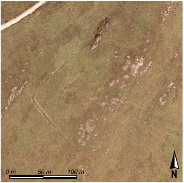
The discovery of the site that we present here has been made possible through the online consulting service of SigPac , that lead to the appearance of some peculiar forms in the terrain (figure 1). After visiting the site and studying the evidences, we interpret these as the structures of a possible archaeological site which we, thanks to the literature available, have identified as a Roman established encampment, probably of military nature.
The site is located on an elevation above the stretch of forest that can be seen toward the west of El Alto de Moyapán, officially known as El Alto de Bustantigo, between the Ayandese parishes of Santa Colomba and Bustantigo, at 21 kilometers of the capital of the county, La Puela / Pola de Allande (figure 2). The location’s coordinates are 43º 20’ 17’’ N; 6º 42’ 30’’ W, and its highest side reaches 1081 meters above sea level.
If we exclude the aforementioned structures, there were no other physical nor intangible elements that might have suggested the presence of a site of this magnitude at this location. The oral tradition in the region did not have the tell-tale signs indicating the presence of other archaeological remnants besides the already known tumuli, the exploitation of the Roman mines, nor were there medieval testimonies. In spite of that it isn’t less interesting to note that many of the names used in the surrounding area do hint at the presence of water bodies and springs, even give reference to an abundance of water: Moyapán in the northwest, Llamaduenas to the west, Fonterroqueiros to the south and El Valle las Llamas to the east.
2. Structural evidence.
The first affirmation we received we were dealing with a new archaeological site, as said, was through aerial photography, as the result from the structural evidence, that has survived up till our days, that shows some very subtle forms—as can be assessed through the graphics that accompany this text. The localizations of these structures by means of an archaeological survey on the ground was a difficult undertaking due to the poor manifestation of its characteristics—the reason why the site has gone unnoticed for Asturian archaeological literature and the relevant inventories and catalogues of archaeological
 sites (González, 1966, 1973; Fernández Ochoa 1982; Camino and Viniegra 1991; Santos Yanguas 1992; Sánchez-Palencia, Orejas y Sastre 2002). Only the verification in situ of the anomalies lead to this new site’s identification that we present in this short note. Moreover we could not identify this new site if it were not for the good and hard work done over the past few years by various teams of Cantabrian archaeologists that brought many new discoveries related to the military Roman occupation of the Cantabrian Region to our shared knowledge (Camino, Viniegra and Estrada 2001, 2005; Camino and others 2007; Cepeda 2006; García Alonso 2001, 2003, 2006; Martínez Velasco 2006; Peralta 1997, 1998, 1999, 2002, 2006; VV.AA. 2006). Starting from these graphics and their descriptions one becomes familiar with these forms and characteristic structures of this type of site, as to recognize – for the moment – the traces of an enclosure of considerable size in county Ayande.
We now will continue with a thorough description of the documented structures in Moyapán, and valuate the site in interpretative manner in a second part of the text.
Figure 1: Aerial view of the enclosure, obtained with the on-line visor of SigPac [http://sigpac.mapa.es/fega/visor/].
2.1. The enclosure: ground plan and form:
The plan of the camp’s enclosure takes on a trapezoidal form, a disposition that favors the perfect adaptability of its defensive structure to the orography and nature of the terrain in which it is situated. Its two largest sides are situated parallel, while the short sides are well closed toward the exterior, in which form it’s adapted to the elevation on which it resides and from where the camp offers a perfect overview of the immediately surrounding terrain. The area of the enclosure measures about 1’5 hectares.
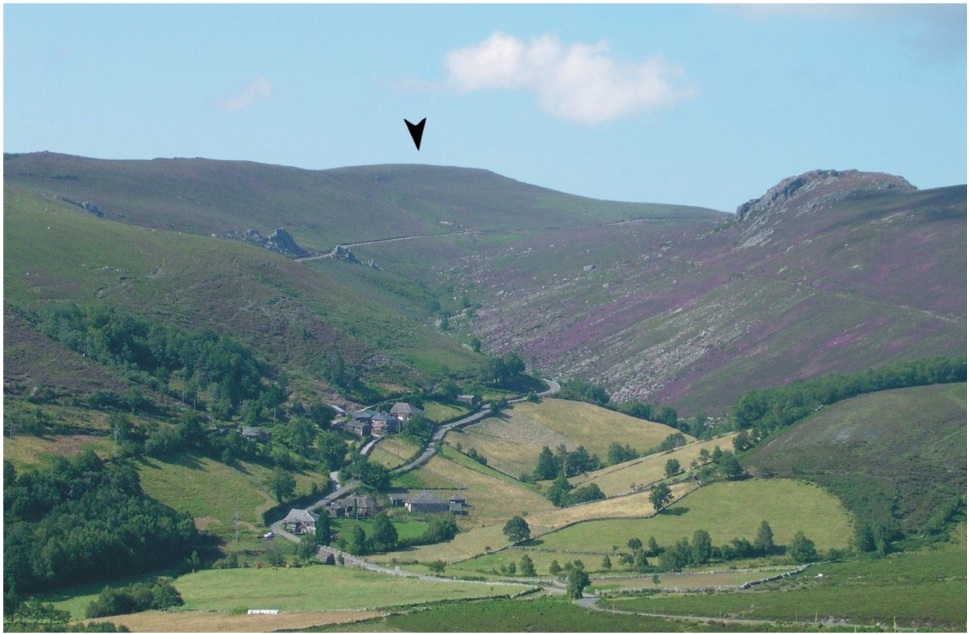
Figure 2: General view of Mt. Moyapán, from La Llabrada, to the south, with the village of El Rebollu on the foreground.
2.2 Defensive structures:
The encampment of Moyapán is primarily defined by its outer limits, given that the interior of the enclosure does not show any discernable traces of structural evidence that can be associated with the use of the site.
The defensive structures limits can be discerned well on three of the sides of the enclosure, while in its southwestern side the demarcation naturally falls off the mountain slope what makes great concern with this side in this respect unnecessary, further than the possible presence of a type of palisade or similar expendable structures placed at the point of the slope’s inflection, where it coincides with the underground of the slate substratum which makes that evidence of such works would be difficult to acknowledge without setting out more intensive archaeological work.
An outline of a mound on the north side (figure 3), between de drop of the southeastern side and the surface appearance of the prominent crag that appears to the north corner, and a continuous line from the vallum (figure 4) in the northwest and southeast sides, that make up the structural elements that serve the defensive boundaries of the site.
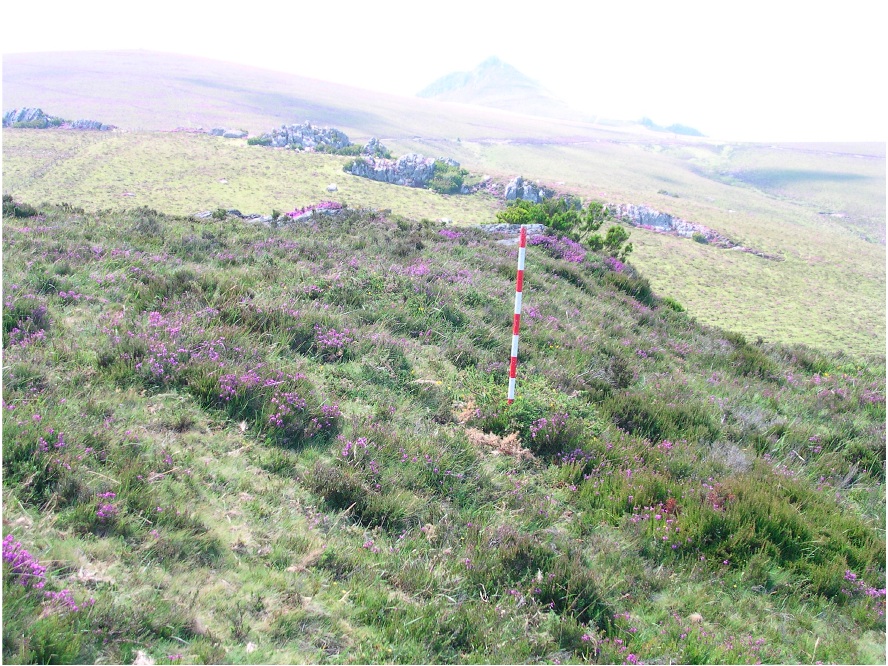
Figure 3: Detailled view on the slope on the north side.
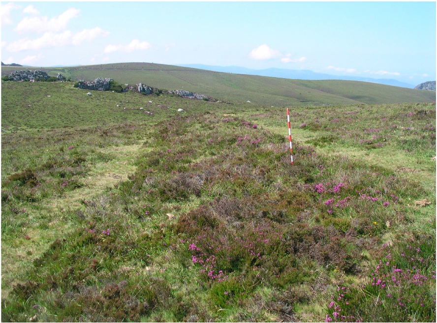
Figure 4: Detailled view of the vallum's line on the northwestern and southwestern sides, with agger and double channel.
The vallum is composed of a small hill (agger) and two channels (fossa) that are filled with earth. In respect to the structure of the agger, notably subsided by corrosion, appears to indicate an inner composition well buried; with its construction most certainly the soil derived from digging out of the two channels was used alongside which they are situated (figure 5).
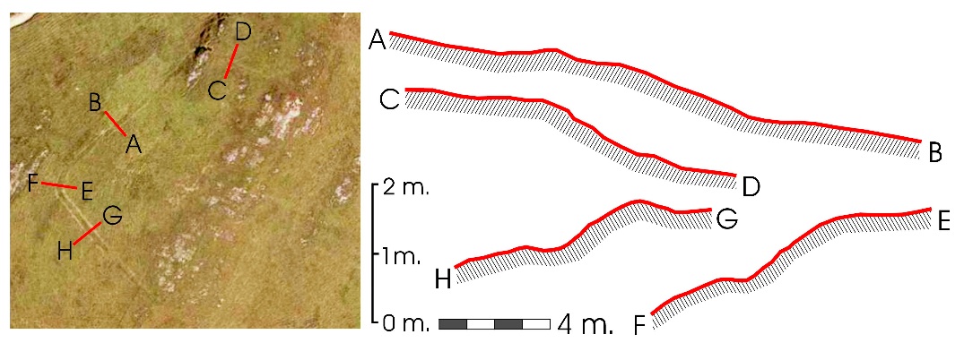
Figure 5: Transversal sections on the the defensive structures at different parts of the boundaries of the enclosure.
This line of the agger would very probably be elevated toward the heights, by means of a palisade (vallum), of a line of stakes with branches (cervuli) or different comparable solutions that involved wooden materials, that could also be pila muralia which the legionnaires used to bring with them. In regards to its conservation the enclosing of the site stands out in its western corner, where the sedimentation is more manifest and emphasizes the entity of the defensive structures of this stretch.
The western corner describes a double traced curve (figure 6), runs away towards the angular closure of the interior, what meant a major risk for the defenders of the enclosure for rendering it more exposed to possible attacks from the outside. Similarly, albeit less prominently than in other remains of the encampment, the contour of the fortification walls seems to turn in a southerly direction before collapsing gradually at the southeastern side.
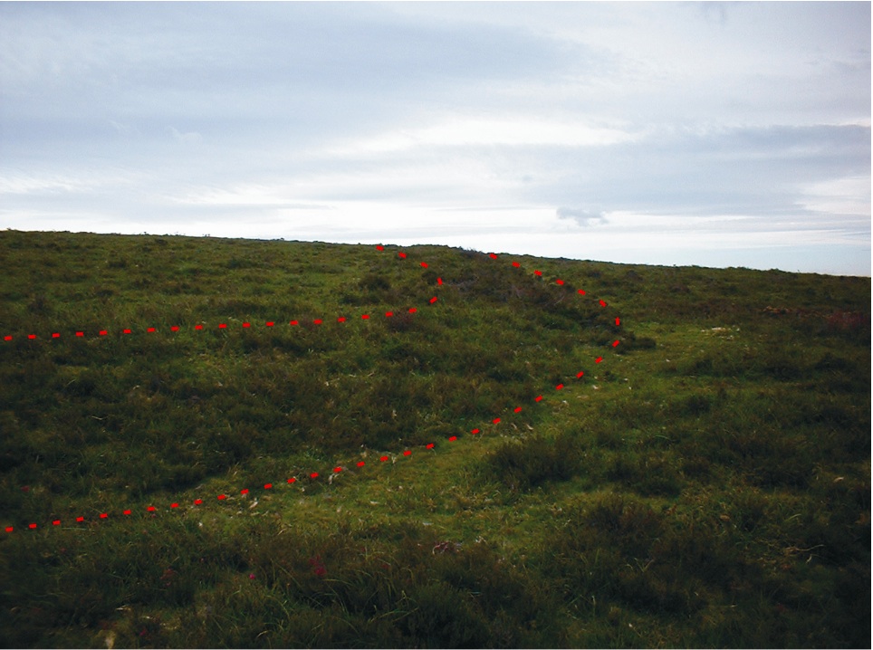
Figure 6: Detailled view of the curved path of the defense line of the west corner.
At the southwestern side we find a discontinuity in the tracings of the vallum over a length of some 9 meters; this we assume to be the gate or entrance of the encampment, even though we have not been able to find the remains of a possible suspended structure that might corroborate the Roman military identity of the location.
2.3 Internal space:
Concerning the internal space of the enclosure, no trace of structures can be seen, nor any signs of occupation. This is due to the abundant vegetation of Erica Vagans and other types of heather that make it hard to discern material remains or other evidence of the type of construction onto the surface. On the other side, the substratum of rock appears through the surface of a large part of the enclosure, especially on the highest sides, where the sedimentary package is very shallow as to contain a large inventory of archeological materials, comparable to what we have seen with similar sites already excavated in Cantabria, Burgos or Palencia (Various Authors, 2006). The only sedimentary package composed of a body that is rich enough and likely will be fit to provide acceptable strategic readings (for its amplitude and continuity) is the terrain close to the perimetral limits which give the fortified enclosure its form—these parts reveal themselves as the most interesting sectors where future works of excavation or intensive survey should take place.
The only evidence of human modifications in the interior of the enclosure comes from a more recent context (although difficult to place chronologically), associated with the delimitation of the zones as pastureland for cattle by means of a small straight water channels that continues for hundreds of meters following the highest point of the mountain range (direction northeast-southeast), since it is marked by small slabs of stone of fixed into the soil. One of those finds itself in the interior of the enclosure.
2.4. State of conservation and condition of the site:
Other facts to present in this first evaluation are about the site’s present state of conservation. Because of its natural structure, its position can be considered as critical, since even the slightest affect, in the form of opening paths, reforestation, placement of power line poles, antennas, or wind generators would put into grave danger the integral preservation of this archaeological site that appears to be of incalculable documental value for the establishment’s understanding of the patterns of its usage, its exploitation and its control of the territory as these were put into practice by the Roman Empire in this region.
In this respect, we should highlight the condition of the encampment’s surroundings in the part where forest firebreaks were dug out in the 20th century, which appears to have involved the space next to the enclosure to the south and the west (although the camp’s perimeter itself seems to be unaffected), which complicates the archaeological estimation of the surroundings closest to the site. It’s lamentable that this damage took place exactly in a space that is so interesting being precisely the area of the enclosure’s entrance, a thing that intricates the evaluation of other structures related to the fortification of the accesses to the camp site.
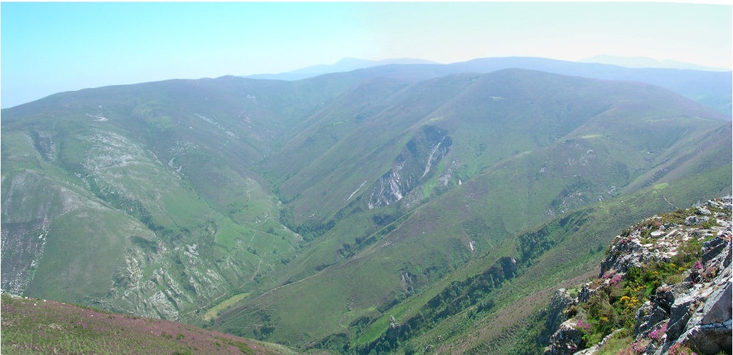
Figura 7: General view onto some of the mineral deforestations on El Río del Oro, in a direct visual line from the very site of Moyapán.
3. Preliminary hypothesis about the works.
Principally, without us being inclined more to the one than the other, we have two options to consider in regards to the interpretation of the site before going ahead with investigative works of intensive research and excavation, needed for the definitive evaluation of the functional or chronological aspects of the enclosure of Moyapán, and furthermore, of its contextual relation to the historic reality into which the location should be inserted:
a) This could be a Roman military encampment that is related to the extensive work of research, planning, control, vigilance or protection of the surrounding area where gold mining operations took place. The visual control over the important mining complex of El Río del Oro (figure 7) that one has from El Alto de Moyapán, cannot escape anyone, especially because of its proximity to the mining sector of El Puertu'l Palu, with mountain passes as spectacular as La Fana de Feitarbosa or La Fana la Freita respectively, (figure 8). The participation of stationed military personal in the exploitative activities of gold mining, is beyond doubt in the peninsular north-west—and this leads us to emphasize this possibility in regard to the contextualization of the site of Moyapán, that may have functioned in relation to gold mining in a similar manner as has been put forward in one of the proposals for the encampment of Valdemeda (León) (Sánchez-Palencia 1986) or one of the Asturian castros showing layers of Roman occupation like El Chao Samartín or San Isidro (Villa 2007: 38-39).
b) We may also be facing a military Roman encampment related to the conquering war campaign at the end of the 1st century B.C. if we follow the parallels of what was recently learned in the region of Cantabria (Peralta 2002; Cepeda 2006; Garcia Alonso 2006; Martínez Velasco 2006; Camino and others 2007). In this line we may allege the formal similarities in structural aspects of the site of Moyapán with the examples mentioned before, and the site’s excellent geo-strategic situation in which the encampment is found, that controls a communication axis of a profound historic tradition connecting the hydrographic basins of the Navia and the Narcea through the highlands of Ayande (Graña 1983). An aspect that would be shared by both interpretative proposals is that the occupation of the establishment very probably was seasonal, because of the height at where it’s located.
Having established our lines of work there’s nothing else to do but hope that other new works about the archaeological site—which we hope will be carried out immediately—will provide new data that will complete and concretize the interpretations that we have put forward here.b) We may also be facing a military Roman encampment related to the conquering war campaign at the end of the 1st century B.C. if we follow the parallels of what was recently learned in the region of Cantabria (Peralta 2002; Cepeda 2006; Garcia Alonso 2006; Martínez Velasco 2006; Camino and others 2007). In this line we may allege the formal similarities in structural aspects of the site of Moyapán with the examples mentioned before, and the site’s excellent geo-strategic situation in which the encampment is found, that controls a communication axis of a profound historic tradition connecting the hydrographic basins of the Navia and the Narcea through the highlands of Ayande (Graña 1983). An aspect that would be shared by both interpretative proposals is that the occupation of the establishment very probably was seasonal, because of the height at where it’s located.
4. In Conclusion.
The encampment of Moyapán constitutes a new archaeological site about which we have constructed through our knowledge of the historic reality of the interior of the western territories, known by the Romans as Asturia Trasmontana. The study of it, therefore, will need to go deeper into questions related to the Roman domination and occupation of the Cantabrian Region: both in forms as in strategies, but also in relation to its economic exploitation and position in it. Therefore, this article constitutes a first contribution to the archaeological questions evoked by this new site at Moyapan, besides a presentation of some first interpretative hypotheses about the same.
In conclusion, it is essential to emphasize the vital need to catalogue, protect and suitably conserve this new archaeological site, whereas the material evidence of the site needs to be evaluated meticulously with archaeological works that are more exhaustive than what we have put forward in this presentation.
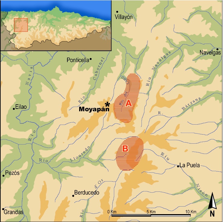
Figure 8: Situation of the site of Moyapán, with roman gold mining areas closest to the encampment indicated as area: A: El Río del Oro, "the gold river" ; Area B: The hills of El Palu.
5. Bibliografía.
———CAMINO MAYOR, J. and VINIEGRA PACHECHO, Y. (1991): “Reseña sobre la Carta arqueológica del concejo de Allande, 1990”, in Excavaciones Arqueológicas en Asturias 2 (1987-1990): 229-31.
———CAMINO MAYOR, J.; VINIEGRA PACHECHO, Y. and ESTRADA GARCÍA, R. (2001): “El campamento romano de la Vía Carisa en Asturia Transmontana”, in Espacio, Tiempo y Forma, Serie I. Prehistoria y Arqueología, 14: 261-276.
———CAMINO MAYOR, J.; VINIEGRA PACHECHO, Y. and ESTRADA GARCÍA, R. (2005): La Carisa. Ástures y romanos frente a frente. Uviéu: Cajastur.
CAMINO MAYOR, J.; VINIEGRA PACHECHO, Y.; ESTRADA GARCÍA, R.; RAMOS OLIVER, F. and JIMÉNEZ MOYANO, F. (2007): “El campamento y la vía de La Carisa. Reflexiones arqueológicas y militares”, in FERNÁNDEZ-TRESGUERRES (ed.): 61-93.
———CEPEDA OCAMPO, J.J. (2006): “Los campamentos romanos de La Poza (Cantabria)”, in MORILLO (ed.): 683-690.
———FERNÁNDEZ OCHOA, C, (1982): Asturias en la época romana. Madrid: Universidad Autónoma de Madrid, Departamento de Prehistoria y Arqueología.
———FERNÁNDEZ-TRESGUERRES, J. (Coord.) (2007): Astures y romanos: Nuevas perspectivas. Uvieo: Real Instituto de Estudios Asturianos.
———GARCÍA ALONSO, M. (2001): “El campamento romano de El Cincho (La Población de Yuso). Un nuevo yacimiento de las Guerras Cántabras”, in Sautuola VIII: 99-106.
———GARCÍA ALONSO, M. (2003): “El campamento romano de El Cincho (La Población de Yuso). Resultados arqueológicos de la campaña del año 2002”, in Sautuola IX: 109- 139.
———GARCÍA ALONSO, M. (2006): “El campamento de campaña de El Cincho (Cantabria)”, in MORILLO (ed.): 549-566.
———GONZÁLEZ Y FERNÁNDEZ-VALLÉS, J.M. (1966): “Catálogo de los castros asturianos”, in Archivum 16.
———GONZÁLEZ Y FERNÁNDEZ-VALLÉS, J.M. (1973): “Castros asturianos del sector lucense y otros no catalogados”, in Cuadernos de Estudios Gallegos XXVIII.
———GRAÑA GARCÍA, A. (1983): “El conjunto tumular de «La carreriega de los gallegos» (Sierra de Carondio, Allande)”, in Ástura, 1: 21-34.
———MARTÍNEZ VELASCO, A. (2006): “Posibles campamentos romanos en el País Vasco: nuevas aportaciones”, in MORILLO (ed.): 691-705.
———MORILLO, A. (ed.) (2006): Arqueología militar romana en Hispania. Producción y abastecimiento en el ámbito militar. Llión: Universidad de León.
———PERALTA LABRADOR, E. (1997): “Arqueología de las Guerras Cántabras. Un campo de batalla en las sierras de Iguaña y Toranzo”, in Revista de Arqueología, 198: 14-23.
———PERALTA LABRADOR, E. (1998): “El último baluarte de los cántabros”, in Revista de
Arqueología, 198: 40-47.
———PERALTA LABRADOR, E. (1999): “El asedio de La Espina del Gallego (Valles de Toranzo y de Iguaña, Cantabria) y el problema de Aracelium”, in Complutum, 10: 195-212.
———PERALTA LABRADOR, E. (2002): “Los campamentos de campaña (castra aestiva): evidencias científicas y carencias académicas”, in Nivel Cero, 10: 49-87.
———PERALTA LABRADOR, E. (2006): “La revisión de las guerras cántabras: novedades arqueológicas en el norte de Castilla”, en MORILLO (ed.): 523-547.
———SÁNCHEZ-PALENCIA, F.J. (1986): “El campamento romano de Valdemeda, Manzaneda (León): ocupación militar y explotación aurífera en el NW peninsular”, in Numantia 2: 227-243.
———SÁNCHEZ-PALENCIA, F.J.; OREJAS, A. and SASTRE, I. (2002): “Los castros y la ocupación romana en zonas mineras del Noroeste de la Península Ibérica”, en BLAS CORTINA, M.A. and VILLA VALDÉS, A. (eds.): Los poblados fortificados del Noroeste de la Península Ibérica. Formación y desarrollo de la Cultura Castreña. Navia: Ayuntamiento de Navia, pp. 242-259.
———SANTOS YANGUAS, N. (1992): La romanización de Asturias. Madrid: Istmo.
———VARIOS AUTHORS. (2006): “Roman military sites in Hispania: an archaeological guide”, en MORILLO y AURRECOECHEA (eds.): The Roman Army in Hispania: An Archaeological Guide. Llión: Universidad de León, 211-381.
———VILLA VALDÉS, A. (2007): “Mil años de poblados fortificados en Asturias (siglos IX a.C.-II d.C.)”, en FERNÁNDEZ-TRESGUERRES (ed.): 27-60.
6. Special thanks.
We want to give thanks for the help and recommendations given by Fernando Álvarez-Balbuena regarding linguistic aspects, beside the information that he facilitated us with about local toponyms. We also feel obliged to give our special thanks to the generous collaboration of the residents of El Rebollu, who gave us the names of the surroundings of El Alto de Moyapán and corrected the cartographic data which we worked with, as well as to our friends who have revised the outline of this article.