From
a cultural, geographical and historical point of view, the Sierra of
Carondio, together with the stream of the same name and the Sierra of
Muriellos, form a unique and exceptional space.
As
the following texts and images show, the Sierra of Carondio, the stream
and the Sierra of Muriellos are the oldest spaces that have been represented
with topographical precision in Asturian and Spanish history. It’s
one of the areas that was among the first represented on a map by man.
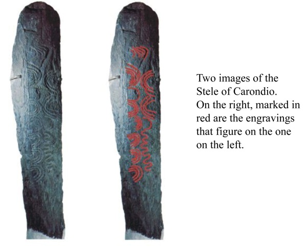
The
Stele of Carondio, inappropriately named the Stele of Allande, represents
a map of the area with topographical accuracy through its curved
lines and undulations. Only this should be enough reason to protect
this area.
The
interpretation of the stele was published for the first time in ‘La
Historia de Gijón’ edited by the newspaper el Comercio in
2001. A revised interpretation, in collaboration with professor Mario
Ruiz Morales of the University of Granada, was published in the journal
Topografía y Cartografía, a publication of the Colegio Oficial
de Ingenieros Técnicos en Topografía, in the 142nd issue of September-October
in 2007.
A Topographic Interpretation.
©2001-2010-
Ricardo González Pañeda and
Mario
Ruiz Morales. (Universidad de Granada)
(This
article was originally published in the series ‘La Historia de Gijón’,
published by the newspaper el Comercio in 2001.)
What
we are doing in this article that we present here, should be the principal
object of any study of prehistoric graphical representation, namely
the attempt to discover the meaning and to arrive at an understanding
of what Neolithic peoples wanted to transmit when they engraved, sculpted
or painted images. Our conviction is that in order to achieve this,
it is necessary to start from the signs themselves, of their form and
structural relation with the space that contains the message (the slab
stone that is the Stele of Carondio in this case) and its cultural,
geographical (place where the find is localized), and historical context.
According to the explanations that are normally put forward by prehistorians,
the series of signs of the stele can be interpreted as a merely decorative
image[1], as a “lithographic” manifestation related
to a funerary cult[2] or as an example of magical practices[3],
although we, in this particular case, conclude that none of these have
been confirmed. We consider the principal line of investigation that
starts with the forms and the signs in themselves, as well as how they
are related on the stele. Within the series of signs on the stele the
undulated line (R1), according to our judgment, appears to
be the key to unravel its possible meaning.
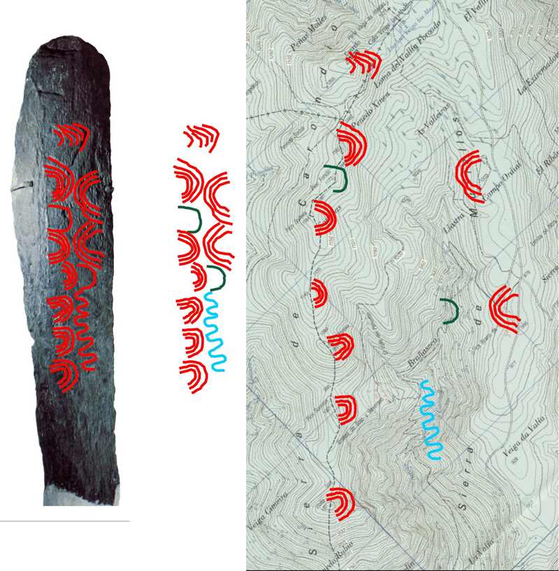
This
line could be interpreted, without too much difficulty, as the symbol
for a stream of water, of a brook or a river. If we accept that the
undulated line represents a river, we can interpret the signs with the
form of concentric arches (C1-C7 and M1-M2)
as images of the relief of the landscape; in this manner the group of
petroglyphs on the stele is nothing other but a series of conventional
signs associated with the plan of a determined area: a real possibility
although improvable in itself—except that in this case the location
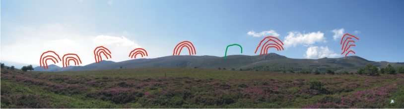
in question can be pinpointed. Keeping in account that prehistoric cartographic
representations had to be necessarily topocentric, we proceeded to examine
the folio of the Mapa Topográfico Nacional nº
50 (Cangas del Narcea. Ed. 2004) to mark the original location of
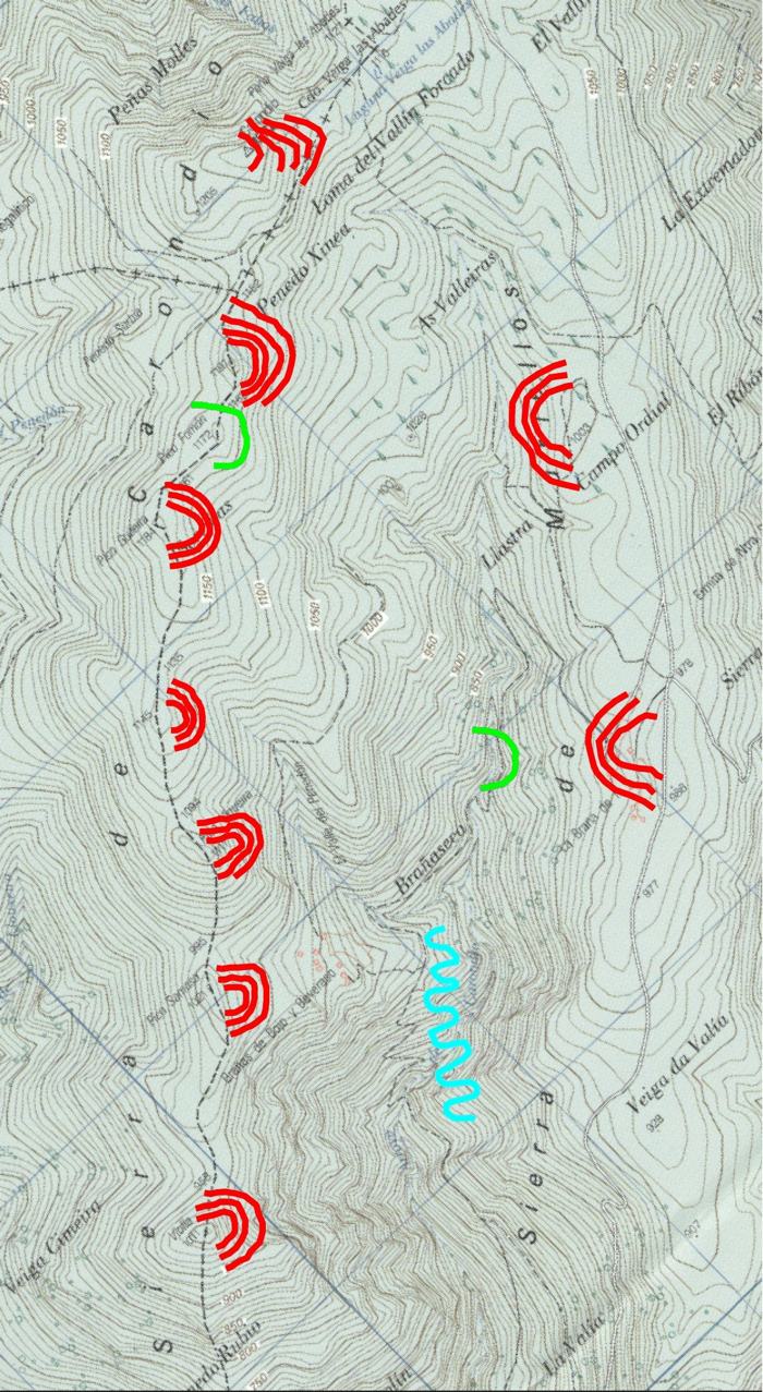
the stele onto it. On this map one can easily observe that the nearest
course of water is the river of Carondio, situated to the south, locked
in between the mountain range of the same name (to the west of the right
side of the stream) and that of the Sierra of Muriellos. On the other
hand, it is necessary to point out the sharp divide between them. In
the first seven or eight peaks can be discerned, in comparison to which
the second, the Sierra of Muriellos, has a much softer relief in which
two hills can be discerned as the most significant geomorphologic elements,
when looked upon from the interior of the valley formed by the creek
of Carondio. When analyzing the planimetric image on the map of both
of them, it shows a remarkable similarity with the columns of signs
engraved on the stele, to be precise, the alignment of the concentric
arches on the left side of the stele(C1-C7)
appears to correspond with the divide mentioned before, while the arches
on the right side (M1-M2) appear to be refer to
the Sierra of Muriellos.
A
new coincidence, that reinforces this hypothesis, is that the two highest
peaks of both mountain ranges are the two peaks most to the north of
the Sierra de Carondio: Pico Carondio with an altitude of 1222 m, and
the peak situated immediately to the southwest, with an altitude of
1191m, coincide with the signs formed by several concentric arches (five
arches, C1, and four, C2). This suggests that
with those signs the maker of the engravings tried to indicate the points
with the greatest altitude.
The
fact that the Sierra of Muriellos has a longitudinal roll-out that is
shorter than that of Carondio explains the empty space on the stele
that can be seen above the concentric arches to the right (M1-M2)
as well as those below them. Ultimately the Peak of Carondio, the highest
of the group presiding over all of the valley, might explain the slight
displacement of the group of five concentric arches (C1)
toward the center of the stele in its upper part, perpendicular to the
undulated line that represents the river. In no way the use of such
signs to symbolize the terrestrial relief should be reason for surprise
because of the clear reminder of cartographic images making use of the
ancestral method of hill profiles: a method that was in practical use
until the 20th Century, when only during the last thirty
years of the latter contour lines became the preferred method for the
representation of heights.
Now
we still have to clarify the meaning of the two single arches (P1
and P2) that are placed between the groups of concentric
arches situated at the second and third place on the left side of the
stone and above the undulated line.
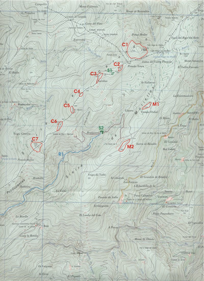
On
the folio of the Mapa Topográfico Nacional, scale 1:25.000 (San
Emiliano 50-I. Ed. 2002) we can, as we perceive it, establish the relation
between concentric arches and the undulated line with the reality that
is represented in the following form:
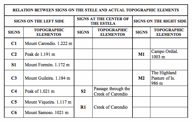
The
signs we have denominated with the letter C, refer to the Sierra of
Carondio. The first signs represent the Peak or Rock of Carondio of
1222 m (C1) and the peak of 1191 m (C2), as already
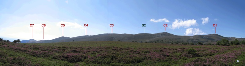
indicated before. Signs C3–C7 correspond
with the five summits of the mountain range that runs from Mount Guileira
to Mount Violla, with altitudes of 1184 m (C3), 1.145 m (C4),
1117 m (C5), 1021 m (C6) and 1011 m (C7),
clearly visible on the topographical map referred to.
Inserted
in the third position between those signs with the form of concentric
arches is the sign that we have denominated S1, with the
form of a simple arch. Within the topographic reality of the location,
this position seems to correspond, with the soft undulation of the terrain
that is found between the peak of 1191 m (C2), second in
height of the mountain range, and the peak of Guileira with a height
of 1.184 m (C3)—whereas the peak first mentioned coincides
with that of Mount Formón with an altitude of 1172 m.
The
signs attributed with the letter M correspond with the Sierra of Muriellos,
as it is seen from the interior of the river valley of the Carondio,
or from the tops of the mountain range of the same name. Sign M1
corresponds with hill of 1003 m of this Sierra, identified on the topographical
map with Campo Ordial, while sign M2 represents the hill
of 986 m, on the map designated as the Braña de Is, the Highland Pasture
of Is.
Sign
R1 corresponds with the representation the river of Carondio
that runs a meandering course between the two mountain ranges.
Sign
S2 is found on the stele between sign M1, placed
above, sign C4 on its left, and sign R1, placed
directly under it. If we place signs M1, C4 and
R1 on the map on top of the topographic elements they seem
to represent, and if we subsequently situate sign S2 on the
map, at the same relative position the stele has, we see that S2
appears to correspond with the passage of the brook of Carondio following
the path that runs from the Highland Pastures of Is (sign M2)
into the direction of the Highland Pastures of Bojo and Beveraso located
in the folds of the Height of Samoso, to which sign C6 corresponds.
Located
between sign C4 that corresponds with the peak and the Sierra
of Carondio, and sign M2 representing the Sierra of Muriellos,
this ford in the stream of Carondio appears to be what is represented
by sign S2.
Hence
these two signs with the form of a simple circumference seem to coincide
on the map with a peak and a ford: two orographic forms that are considered
opposites but that nevertheless are represented here by the same sign.
In our opinion these two signs are no clear pictograms that can be as
easily interpreted as the ones that have the form of grouped arches
representing hills, or the undulated line depicting the river. In the
case of signs S1 and S2 we are dealing with
ideograms, that is to say, we have two signs that, although we assume
they represent two distinct geographical realities, can be pinpointed
through the context of their geographic situation. In this manner they
would be represented by a different idea of the orographic form than
the ones they coincide with topographically. We propose these signs
with the form of a single arch should be interpreted as ‘gates’.
In this manner they could represent the entrance into two different
territories, and so the ideogram may possibly be related to the concept
of a territorial boundary.
In
consequence, what we consider most probable is that the representation
on the stele shows the territorial division between two communities,
of the space comprised by the Sierras of Carondio and Muriellos and
the river that runs in between them. Using Mount Formón (S1)
and the place where a path runs between the Sierra of Muriellos and
Carondio that crosses the river of the same name (S2), this
division was made of the territory used for economic exploitation by
two communities. The other signs (C1–C7, M1–M2
and R1) form a descriptive map, in a realistic language that
uses the pictogram as the medium to express its clear message: the actual
space they meant to divide.
In this manner the Sierra of Muriellos, that heads the small valley formed by the river, and the two highest peaks of the Sierra of Carondio (signs C1 and C2, and M1 and M2—the signs on the stele placed above S1 and S2) would correspond with the territory of a group of people that supposedly lived on the SE side of the Sierra of Muriellos, precisely where the communities of Muriellos, Bedón and Is are located in the present; its people, just like in our time until a few decennia ago, would have exploited the Highland Pasture of Is. The rest of the space, i.e. the lowest peaks of the Sierra of Carondio and the river valley (signs C3–C7, and R1) pertained to a different community that lived on the south-side of the mountain ranges—where nowadays the communities of Bevaraso and Bojo can be found. These peoples exploited the highland pastures of Bojo and Bevaraso. Formon Peak and the ford on the path that connects the two highland pastures (signs S1 and S2) would form the territorial boundaries between the two groups.
In
conclusion we hypothesize that the Stele of Carondio is an easily recognizable
map, represented by clear, easy to identify pictograms symbolizing groups
of hills on mountain ranges and a river. A map that shows an indubitably
topographic reality not open to any doubt, and that could be taken for
what they actually tried to do with it: make a division of the territory
present between two communities. To do this two signs were used too
that are not pictographs, but ideograms with the signification of ‘boundary’
that took advantage two orographic realities: a ford and a peak that
in themselves have no representation, but which can be recognized and
comprehended through their location on the map.
The reliability of the cartographic interpretation that we offer here gains greater probability if set off against the folio corresponding with the Mapa Topográfico Nacional that offers the most representative altimetric details. The conclusion is obvious: the megalith was a vision of the landscape as it was seen from its original location: a remote ancestor of the panoramic viewpoints that adorn many touristic routes of special interest. The interpretation presented here does not suppose anything new[4], given what already has been said and written about the specimen found in Tepe Gawra (Iraq) and in Talat N´Iisk (Marroco) that bear great similarity with the image represented on our stele. Yet at the same time we believe that this is the first occasion on which cartographic petroglyphs in Spain have been identified and that many more of those will appear if we would re-examine a number of previous finds with approaches that complement the conventional and numerous cases that are duly documented already.
[1] One could assign a merely decorative function to the representation, ornamental, in which the abstract signs had the aim to embellish the orthostat on the basis of forms de that may have had a meaning of a religious or funerary character, remote and incomprehensible. But the lack of symmetry, the abundance of spaces without decorations and the lack of connections between the signs, that appear to be in disorder, make such an interpretation very unlikely
[2] A second interpretation, the most usual, about megalithic art, in the words of Bueno and Balbín (Una geografía cultural del arte megalítico: las supuestas áreas marginales, on the first International Symposium about Prehistoric Art of Ribadesella. Prehistoric Art since the beginning of the 20th century. 2003) is the “expression of the mythology of death (p. 300)” or “a graphic sign associated with the sphere of death (p. 303)”; this would serve as the key to discover the meaning of the group of signs, of the undulated line that formally could be interpreted as a serpentiform, the schematic representation of a serpent. Hence we’d be dealing with a sample of a funerary-mythological narration in which the serpent is given a symbolic value as emblem of the death of the earth, of the hidden but alive, and the concentric half-circles would become ova and eggs, symbols of life and of resurrection, or in engraved rocks symbolizing the earth. These interpretations are suggestive and profoundly subjective, but have no single fundament except the support of the well-known eternal myths about death, hence not provable; and therefore we consider this lecture little likely and improvable.
[3] A third and suggestive interpretation that we could propose here, would be to relate the signs with “shamanistic” practices, following the proposed lines, like interpretation of the art of Paleolithic caves, by J. Clottes y D. Lewis-Williams (Los chamanes de la prehistoria. Barcelona 2001). According to these authors “in the first stage of [shamanic] trance, the lightest, one sees such geometric forms such as points, zigzags, grilled lines, series of lines or of interconnected parallel curves and meandering lines (p. 15)”, but we see too much order and a lack o spontaneity (these are laborious, structured and premeditated engravings), and it is impossible that these have been made in a state of altered consciousness, although they may have been produced after the trance “to resuscitate and recall the visions (p.86)”.
[4] Actually, a summary of this article already appeared in one of the special publications of la Historia de Gijón edited by the newspaper El Comercio in the same city and written by the first author of this article.