THE TUMULAR GROUP OF THE “CARREIRIEGA DE LOS GALLEGOS”
(The Sierra of Carondio, Allande - Asturias)
(The Sierra of Carondio, Allande - Asturias)
Armando Graña García.
Originally published in: Astura, Nuevos cartafueyos d'Asturies 1/83. Xixón. pp. 21-34; 1983.
The coordinates in this article refer to the Meridian of Madrid.
The coordinates in this article refer to the Meridian of Madrid.
The Sierra de Carondio is part of a group of mountainous alignments with the name of Sierra de Rañadoira. This alignment splits off from the extreme west of the Cantabrian Mountains, at the mountain pass of Rañadoira, from where it follows an approximately South to North direction, up to the Cantabrian coast where it descends between the towns of Luarca and Navia. It comprises the areas of Rañadoira, Valvaler, Valledor, el Palo and Leirosa, and is grouped into two larger areas, the southern with more notable heights (1.700-1.300 m), and the northern of lesser altitude (1.100-1000 m); the Puerto del Palo, in the middle, marks the boundary between these two.
Geologically it is laid out over a terrain with a primary foundation of slate and quartzite from the Cambrian and Ordovician. These materials were folded during the Hercynian orogeny, and later came under the assault of erosion that reduced its original relief to peneplains; new tectonic movements during the Alpine orogeny broke the ancient materials into blocks, which rejuvenated the relief and reactivated the erosive phenomena, which as such pushed the folded Hercynian structure back to the surface once more.
To the East this grand topographic phenomenon demarcates the hydrographic basins of the rivers Narcea, and Navia to the West; furthermore it acts as the ethnographic, linguistic and administrative boundary, marking the contact between Western Asturias and the area of Galician influence.
The mountain range of Carondio starts from the middle of these mountains, at the outskirts of County Allande (1); it constitutes a westward buttress with a zigzagging pattern into NW, SW, NW direction, until it descends into the riverbed of the river Navia. (Fig. 1.).
Topographically the flattened forms of the high zones predominate, bearing reminiscence of the ancient dislocated peniplains, with an altitude of 1.100 m and without important differences in altitude. In contrary, the rivers cut deeply into this surface, giving rise to very steep sides, and valleys with a V-profile. The smoothest relief enfolds slate, often showing crests and spurs of quartzite, which is far more resistant to erosion because of its hardness.
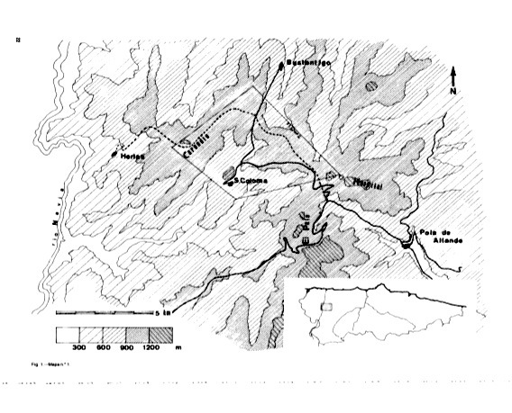
Fig. 1.—Map n.º 1.
Nowadays the forest vegetation has retreated to the deeper parts of the valleys and to the most protected sides. Villages and cultivated grounds—of very small dimensions—are located on the smoothest sides; the highest parts have meadows and scrubland on them. During the last decades an extensive reforestation of the communal mountains has been wedded to a general rural abandonment, which has aggravated the problem of the area’s desertification.
POPULAR TRADITIONS & THE TUMULI OF CARONDIO.
There are many legends in nearby villages that make reference to the existence and discovery of treasures. This usually happens in hidden caves, at rocks with capricious forms, or in the remains of the ancient mining works that are abundant in the Sierra de Palo and the valley of Bustantigo. Furthermore, a typical confusion exists in the name giving of tumuli and small water reservoirs for the exploitation of mines that are both called “tomb” (tumba) or “waterhole” (pozo).
The most widespread legend refers to the Dolmen of Entrerrios, also know as the Llastra a Filadoira, because the large slab stone that covers the chamber was supposedly carried there on the head of a woman who was spinning while she walked. Another widespread belief is that the tombs were made by the “moros” [an ancient, pre-Christian people, large and dark skinned; this does not refer to the Muslim moors. —note transl.].
In Penouta they remember how at the beginning of the last century a traveler poked in a “waterhole” at the Sierra de la Cabra, and found a lot of small stones, cut like knifes, which he took with him “in a small bag”; a local of the village of Llaneces who saw him, dug there the next day and found more stones of this type. (2).
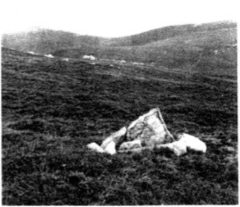
Foto1.—Slabs of the chamber of Pico Llangominos.
A similar story is found in El Sellón according to which some peasants did an excavation, also in a “pozo” at the Corradas de Carondio (which couldbe an equivalent toponym for Corralón), and found a “small cauldron” containing something like sand, but shiny like metal powder (3).
Although not directly related to the tumuli, there are stories describing rocks with “signs and drawings” on them located near the tumuli, but we have not been able to locate them. One of these stones is supposedly in La Veiga Zapateya. Another was said to be found in a cave in the Sierra de Muriellos, a mountain range situated next to the Carreiriega. The story claims that there is “a table with a diamond on top of it”, and that a miner entered the cave that was so deep that his carbide lamp went out before he reached the end of it.
Close to another tumulus, found on the hill named Pozo, there are reports of a rock with a gate in it. This rock is the first one that receives sunlight in the morning. If you enter through its gate you come into a cave where a table is set, covered with golden cutlery, guarded by a golden snake. Other versions say that there’s a pig inside with golden piglets.
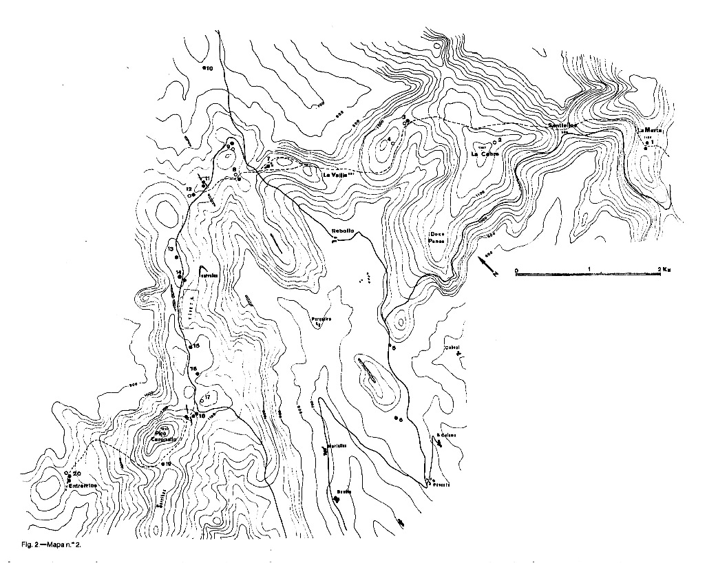
Fig. 2.—Map n.º 2.
THE TUMULI.
The existence of prehistoric structures in the Sierra de Carondio is known through a short reference to “several stone graves of pre-Christian peoples”, made by the Count of Toreno at the end of the 18th century (4).
A century later, Acevedo and Huelves publish a note about the Dolmen of Entrerrios, beside other very imprecise references to tumuli located on the right bank of the river Navia, at the outskirts of County Allande (5).
More precision is offered by the facts gathered by Aurelio de Llano (6) who identified a “dolmenic necropolis” next to the “carreiru de los gallegos”, and published a photograph of the dolmen of Entrerrios.
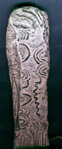
A little earlier the so-called “dolmenic stone of Allande” becomes known, and is studied by the Count of Vega de Sella, but without specifying its precise origin (7). This is a slab of slate-like stone with engraved decorations, and apparently it formed part of a dolmen.
After that the contributions to the knowledge of the characteristics of the tumuli of Carondio are sparse: in 1963 Jordá catalogues the known dolmen of Asturias including the one of Entrerrios (8); Antonio García Linares, in a concise synthesis of widely varied aspects of County Allande, pointing out the toponymical localization of the tumulus of Carondio (9).
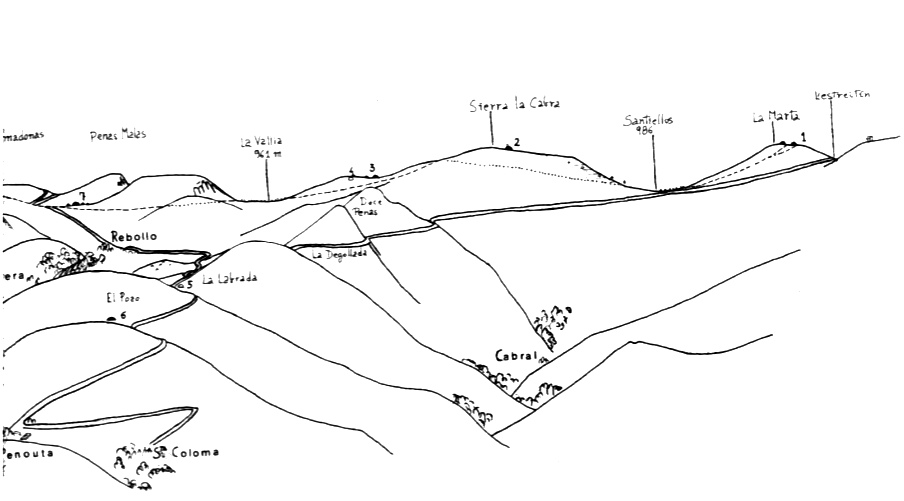
The tumuli are placed in a spreading along the mountain range of the Sierra de Carondio, starting at its junction with the Sierra del Palo, following the “Carreiriega de los Gallegos”, as a path laid out over the heights of the range, connecting the basins of the Navia and the Narcea rivers. It has much been in use until the middle of the 20th century, and its path parted from the proximities of the village of Herias, to climb onto the hill of Entrerrios and, continuing through Carondio and La Cabra, arriving at the Sierra del Palo at La Marta; at this point the way bifurcated and could either be followed through the Sierra del Hospital toward Lavadoira, or descending to la Pola via the way of Puerto del Palo (fig. 2).
The Campo de la Marta, to the east, and the pass of Carondio, to the west, mark the highest points of the way, at some 1.150 m, and maintaining its direction in between them (for about ten kilometers) at a slightly lesser altitude but without important differences in height. The lowest points correspond with the passages of Santiellos, at 986 m, and that of La Vallía, at 961 m. Between these two the Sierra de la Cabra is located, to the east of Santiellos is the one of La Marta, and to the west of la Vallí¬a that of Carondio. The field of Entrerrios marks the beginning of the descent toward the riverbed of the Navia (fig. 3).
The “Carreiriega de los Gallegos” currently is accessible from the non-asphalted road that starts from the road from Pola de Allande to Puerto del Palo, at the height of the kilometric point 20, and that arrives to the location of Penouta, with a branch that passes through Penas Malas toward Bustántigo. The first stretch of this way climbs up the pass of Estreitín, going south and is very close to the Campo de la Marta—from where we begin our description.
The local denomination for the tumuli is “tomb” (“tumba”; equivalent for coffin or stone case), completed with the reference of the closest topographic features: a peñasco, “peneo” [crag], campo, “veiga” [lowland], etc..
CATALOGUE AND DESCRIPTION OF THE TUMULI .
(Coordinates used are according to the Meridian of Madrid)1. Tombs of La Marta.
Coordinates: 2º58'40'' long. W (10); 43º18'05” lat. N. Altitude 1.150 m.
Two tumuli situated on the hill of La Marta, at both sides of the way, which begins its descent to Santiellos at this point, and very close to an “antigua” [waterhole] (11) that lays along the Sierra del Palo in N-S direction, and toward a small pool, a storage tank, also related to the Roman mineral exploitations.
Tumulus A. To the north of the way, with an unevenly conserved tumular mass, and affected by extensive plundering of the central pit. Its east border coincides with the end of the pool, and the southern with the way. None of the stones of the structure of the tumular body can be discerned.
Dimensions of the tumulus diameter E-W: 15 m. Diameter of the pit: 6 m. Maximum height: E-side, 1.40 m. Depth of the pit: 1,20 m.
Tumulus B. At some eight meter to the south of the way. Covered by dense vegetation, it is much smaller and better conserved.
Dimensions of the tumulus: diameter E-W: 8,50 m. Diameter of the pit: 2,50 m. Maximum height: 1,20 m. Depth of the pit: 0,60 m.
2. Tomb of Pico Cuayeiro.
Coordinates: 2º59'40" long. W; 43º19'00" lat. N. Altitude: 1.150m.
Tumulus at the Sierra de la Cabra, close to the peak of Cuayeiro, and set apart from the route that passes much lower on NW slope. It is located in a zone reforested with pines, that were burnt a few years ago. The tumular mass is dismantled in its northern side, where the quartzite of the underground comes to the surface, which seems to be composed of quartzite blocks. In the plundered pit a slab is found, presently stuck up like a milestone, that could be the remains of the possible chamber. It measures 1 m in height by 40 cm in width.
Dimensions of the tumulus: diameter E-W: 10 m; diameter of the pit: 3 m. Max. height: 1,40 m; depth of the pit: 40 cm.
3. Tombs of Llangominos.
Coordinates: 3º00'00” long. W; 43º19'30'' lat. N. Altitude 1.022 m.
Two tumuli situated on the hill of Llangominos, on the banks of a pool.
Tumulus A. About eight meter to the E of the pool, with a tumular mass very well conserved, although with deep plundering of the central pit.
Dimensions of the tumulus: diameter E-W, 11 m; diameter of the pit, 4 m; maximum height 1,70 m; Depth pit, 1,60 m.
Tumulus B. Situated to the west of the pool, it’s almost completely dismantled, leaving its boundaries very unclear and its relief flattened.
Photo 2. —Hills and Tombs de Llangominos.
4. Tomb of Pico Llangominos.
Coordinates: 3º00'20” long. W; 43º19'55” lat. N. Altitude 1.045 m.
A tumulus situated on the southern slope of Pico Llangominos, at about eighty meter of its top. Its tumular mass has almost completely disappeared, leaving open to the air the slabs that formed the chamber of quartzite, four in place, and the other displaced and fallen on the ground, which may be the covering. They form a rectangular space, of approximately one meter in length at maximum.
Dimensions of the tumulus: diameter E-W, 8 m; diameter of the pit, 5 m; max. height 0,5 m.
5. Tomb of the Labrada.
Coordinates: 3º01'40” long. W; 43º18'30” lat. N. Altitude 888 m.
A tumulus located on the hill of La Labrada, above a secondary mountain range that descends from the Sierra de la Cabra. It has been affected by the excavation of the trajectory of the access road to Penouta, presently reducing it to a malformed quadrant, which in its higher sides shows the composition of the landmass, containing earth of dark color and a few blocks of quartzite (12).
6. Tomb of the Pozo.
Coordinates: 3º02'10” long. W; 43"18'00" lat. N. Altitude 860 m.
A tumulus situated halfway on the way from La Labrada to the village of Penouta, on the hill of El Pozo, and close to the access road to this village (13).
Dimensions: diameter E-W 13 m; diameter of the pit. 3 m; max. height, 1.30 m; depth of the pit, 1 m.
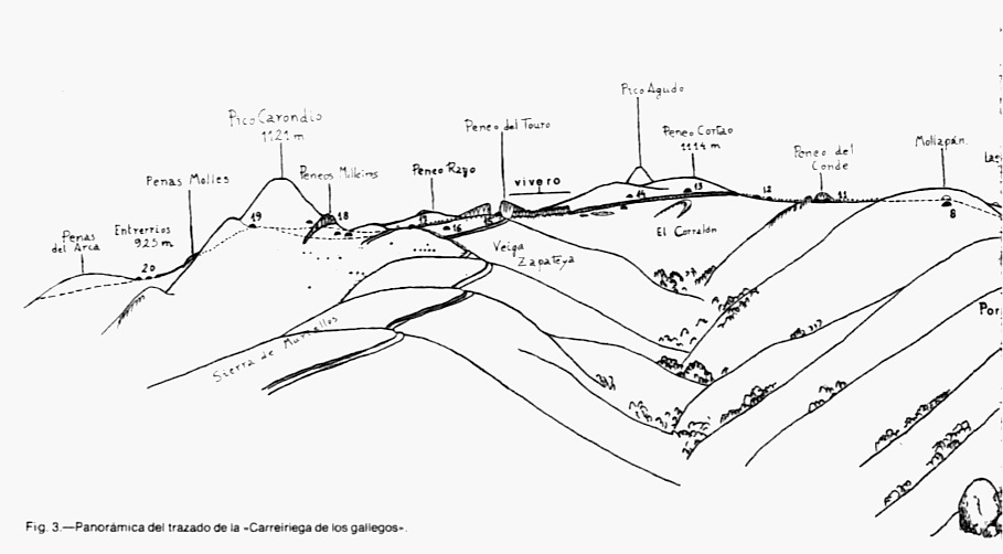
Fig. 3. —Panorama of the alignment of the “Carreiriega de los gallegos”.
7. Tombs of Penas Malas.
Coordinates: 3º01'20'' long. W; 43º19'55'' lat. N. Altitude 1.025 m.
Four tumuli located on the hill to the west of the height of Penas Malas, through which the way passes from Rebollo to Bustantigo; one of them has considerable dimensions, while the other three have a very small size (fig. 4).
Tumulus A. At 8,50 m to the west of the largest tumulus, is of small dimensions, but very visible because it is free of vegetation. In the small central pit small stones come to the surface.
Dimensions of the tumulus: diameter E-W 5,50 m; diameter of the pit, 0,50 m. maximum height, 0,50 m.
Tumulus B. Its tumular mass reaches high, but is very affected by the extensive plundering of the pit; it shows an oval plan, partly due to the accumulation of materials displaced by digging, and it seems to be composed of soil and numerous blocks of quartzite of small dimensions.
Dimensions of the tumulus: diameter E-W, 19 m; diameter of the N-S, 14 m; height 1,80 m.
Dimensions of the pit: diameter of the. E-W, 9 m; diameter of the. N-S, 6 m; Depth 1,30 m.
Tumulus C. About 10 meter to the NW to the exterior side of the tumulus B, and with similar characteristics as tumulus A.
Dimensions of the tumulus diameter E-W, 4,70m; diameter of the pit, 0.80 m. alt. 0,40 m.
Tumulus D. About six meter to the south of tumulus C; with this and with A it forms a very pointed triangle that encloses tumulus B. Like the first, it finds itself masked by dense vegetation.
Dimensions of the tumulus: diameter E-W 4,50 m; diameter of the POZO, 1.50 m. Alt. 0,50 m.
In the space comprised between the tumuli B, C and D, a relief can be observed that seems to be part of an ancient wall of dry stones, or simply a linear pile-up of quartzite blocks (fig. 4, E). The most recognizable part forms a straight angle, slightly bent, and appears to have two parallel walls to the north. The group forms a rectangle, of six meter by nine, and with thickness of one meter, without elevating more than 40 cm. (14).
8. Tombs of Mollapán.
Coordinates: 3º01'30" long. W; 43º20'00" lat. N. Altitude 1.060 m.
Two tumuli, one of them devastated, to the south of the Pico Mollapán, on a hill crossed by the ancient way that separates them. The northern tumuli are located on the line of a firebreak that was laid out at the reforestation of the mountain; presently there is no other sign of that reforestation.
Tumulus A. Very affected by plundering and by firebreaks, the central pit practically occupies all of the tumular area, due to which the mass is reduced to a circular enlarged ring toward the east through the accumulation of earth extracted from the pit. There are two slabs of slate, the ancient orthostats are displaced.
Dimensions of the tumulus: diameter E-W 14 m; diameter of the pit 7 m; max. height 0,90 m; Depth of the pit, 0,90 m.
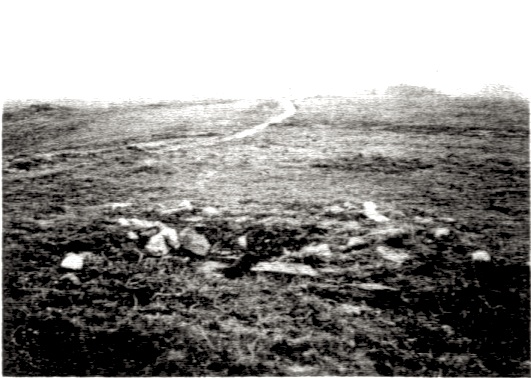
Photo 3. —La Carreiriega seen from the Tomb of the Peneo Cortao.
Tumulus B. Located to the north of the way, and completely devastated; it only is recognizable due to the presence of six slate slabs buried into the earth, and that stick out some 50 cm, forming an incomplete semicircle with a diameter of 2.50 m. Close to them is another slab that has fallen onto the ground, measuring 2 m in length by 1,50 m in width.
Therefore it seems that these remains corresponds with the chamber of a tumulus although there is not sufficient evidence for this.
9. Tombs of the Llamadonas.
Coordinates: 3"01'30" long. W; 43º20'20" lat. N; altitude 1.050 m.
Two tumuli situated between the access road to Carondio and the peak of Mollapán, also called the Llamadonas, on the banks of a pool.
Tumulus A. To the west of the pool, and placed on the slope of the Llamadonas. A well-conserved tumular body, slightly deformed by the accumulation of materials of the pit in its east side. Contains a slab of slate inside its pit.
Dimensions of the tumulus: Diameter E-W, 20 m; diameter of the N-S, 16 m; alt. max. 1,10 m.
Dimensions of the pit: diameter E-W, 9 m; diameter N-S, 7 m; depth 0,90m.
Tumulus B. In the other bank of the pool, and at some thirty meter from tumulus A; mostly devastated, hardly sticks out from the soil.
Dimensions of the tumulus: diameter E-W, 11 m; diameter of the pit 3 m; height 0,30 m.
10. Tomb of the Campo de las Carballeiras.
Coordinates: 3"01'20" long. W; 43º20'50" lat. N; Altitude 978 m.
A tumulus situated on a wide hill of the Sierra de Bustantigo, a secondary mountain range descending from the Llamadonas toward the north, and that runs along a road, to the side of which the east tumulus is located that is irregularly conserved, and with material running out of the pit toward the west, that has left it deformed. It contains three flagstones stuck in the bottom of the central pit, that stand out some 70 cm; the tumular body is composed of small flagstones of slate, much present in the substrate of the surrounding terrain.
Dimensions of the tumulus: diameter E-W, 9,5 m; diameter of the pit 4 m; maximum height 1,30 m; Depth of the pit 0,50 m.
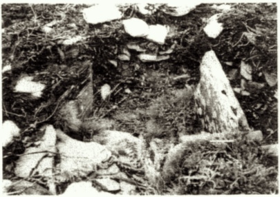
Photo 4. —Chamber of Peneo Cortao.
11. Tombs of the Peneo del Conde.
Coordinates: 3º01'50" long. W: 43º20'20" lat. N; Altitude 1,060 m.
Two tumulus located next to the rock with this name, quartzite surfacing perpendicular on the direction of the way; this runs parallel to a forest path laid out during reforestation works and that parts from the way between Rebollo and Bustantigo, a the height of the hill of Penas Malas (15).
Tumulus A. Just next to the way; tumular mass well conserved, with a central pit in which three stones are found that form the chamber of quartzite, two of them parallel, and the third, that would correspond with the covering, presently dislocated and fallen down. The resulting plan is rectangular, although with less opened sides, because the original slabs have disappeared; the largest axis is oriented into the direction E-W (Fig. 5)
Dimensions of the tumulus: diameter E-W, 13 m; diameter of the pit 4,50 m; height. 1,40 m.
Dimensions of the internal width of the chamber: 0,75 m; visible height 0,70 m.
North stone, width 1,25 m; southern slab, width 1,55 m: covering slab, 1m.
Tumulus B. Ten meter to the NW of the first, and with a deep pit due to plundering; many loose blocks of quartzite.
Dimensions of the tumulus: diameter E-W, 10 m; diameter of the. pit 4,20 m; alt. 1m.
12. Tombs de the Veiga of the Conde.
Coordinates: 3º0l'60" long. W; 43º20'20" lat. N; Altitude 1.060 m.
Two tumuli situated about 50 m. to the west of the Peneo del Conde.
Tumulus A. Presently the tumular mass is mostly dismantled, in it five stones surface that formed the chamber, all slabs of slate except one that is of reddish quartzite. Three of them delimit a rectangle, somewhat deformed by displacements of the smaller slab; all are half-buried, without possibility to observe their total height, and without having a real pit in the center of the tumulus (Fig. 6).
Dimensions of the tumulus: diameter E-W, 9 m; height 0,40 m.
Dimensions de the chamber: slab N, width 1,40 m; slab S, width 1,40; slab W, width 0,90 m; the interior space of the chamber measures 1.40 m. by 1 m.
Tumulus B. Laterally crossed by a path, and its mass has sunken much; it contains three large flagstones de quartzite delimiting a rectangle, and another displaced stone that may have been the roof (Fig. 7).
Dimensions of the tumulus: diameter E-W, 14 m; diameter of the pit 2,50 m; alt. 0,60 m.
Dimensions of the chamber: 1,50 m by 0,60 m. Los orthostats stand out 0,50 m. north slab: visible width, 1.10 m; north slab, total width 1,50 m; west slab, width 0,50 m.
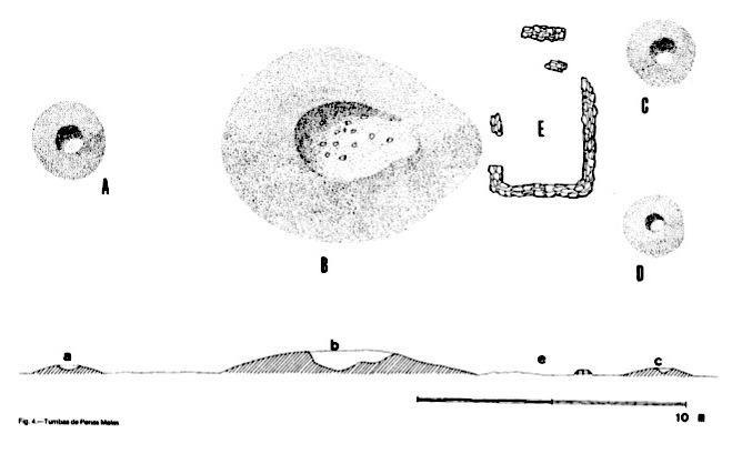
Fig. 4. — Tombs of Penas Malas.
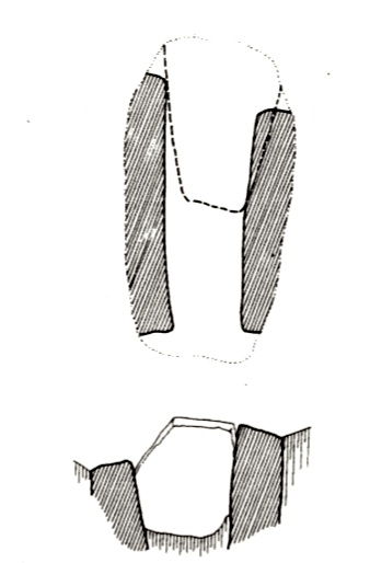
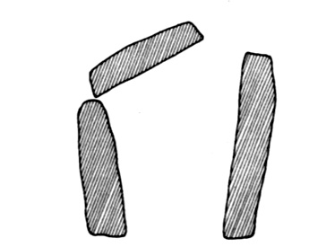
Fig.5. —Plans and sections of cistas: Peneo del Conde A. Fig.6. —Plans and sections of cistas. Veiga del Conde A.
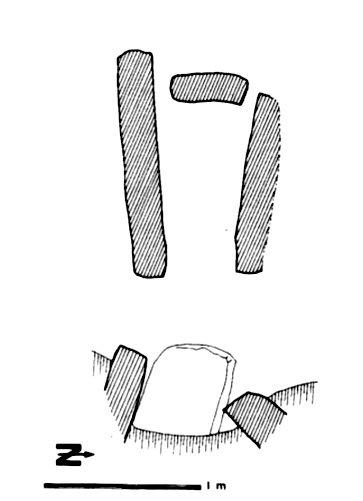
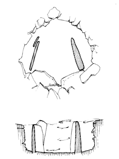
Fig. 7. —Plan and sections of cistas: Veiga del Conde B. Fig. 8. —Plans and sections of polygonal chambers: Peneo Cortao.
13. Tomb of the Peneo Cortao.
Coordinates: 3º02'20" long. W; 43º20'00" lat. N; Altitude 1.110 m.
A tumulus on the east slope of Peneo Cortao, close to a forest path; tumular mass well conserved, but with a very deep central pit, that exposes the stones of the chamber to the open air. The freshness of the sides, almost clear of vegetation seems to provide evidence that the last earth moving happened only shortly before our visit. The chamber in its current state is composed of two orthostats still in place, two more fallen down, all of slate; one can also make out the composition of the tumular mass, in the form of small slabs of slate and quartzite (Fig. 8).
Dimensions of the tumulus: diameter E-W, 11 m: diameter of the pit 1,80m; alt. 0,90m.
14. Tombs of the Corralón
Coordinates: 3º02'30" long. W; 43º19'50" lat. N; Altitude 1.100m.
Two tumuli located in the Veiga of the Corralón; they owe their name to the Peneo del Corralón, a synclinal substrate of quartzite, that adopts a semicircular form, comparable to a pen for livestock, situated to the east of the Veiga, and close to some small lagoons.
Tumulus A. To the NO of the forest path, it is in use as placeholder for a road sign delimiting a hunting area [Coto de Caza]. Well-conserved mass.
Dimensions of the tumulus: diameter E-W, 19m; diameter pit 3,50m; height 1,40m.
Tumulus B. Some thirty meter to the SE of tumulus A; central pit in which one orthostat of quartzite remains standing, slightly inclining forwards; there are another two other slabs of slate which have fallen onto the ground.
Dimensions of the tumulus: diameter E-W, 14 m; diameter of the pit 2,50m; alt. 1.10m.
Depth pit, 0,80 m. Dimensions de the slab: height 1,40m; width 0,50m; thickness 17cm.
15. Tomb of the Castellín.
Coordinates: 3º03'00'' long. W: 43O19'30" lat. N; Altitude 1.100m.
A tumulus situated high on the hill of the Castellín, that is separated from the Corralón by a wide field, partially used as a breeding ground for pines for reforestation, and that presently is a small thin forest. Opposite to the breeding ground is the Peneo del Touro, a rocky peak of very characteristic form. From this tumulus the “Piedra Dolménica de Allande” originates; presently the tumular mass shows a dug out pit of large size with materials running out from the east side, and without any evidence of chambers or quartzite slabs, although there are plenty of quartzite blocks of small size.
Dimensions of the tumulus: diameter E-W, 17 m; diameter of the pit 6 m; height 1,80m: Depth pit 1.60m.
16. Tomb of the Rego del Buño.
Coordinates: 3º03'10"long. W; 43º19'25" lat. N; Altitude 1.105m.
Tumulus situated in the river valley of this name, also called “Campu el Rayu”. Large tumular mass, set into the somewhat sloping terrain, with a dug out pit of little depth, in this two slabs of quartzite come to the surface, forming a rectangle from which the flagstones on the short sides (east and west) have disappeared; there are two more slabs, half-buried above the tumulus
Dimensions of the tumulus: diameter E-W, 17 m; diameter of the pit 3m; height 1,80m.
Dimensions of the slabs: height visible 0,40m; width 1,50m; internal width of the chamber (N-S) 1,60m.
17. Tomb de Veigosabades.
Coordinates: 3º03'20" long. W; 43º19'20" lat. N; Altitude 1.120m.
Tumulus of sufficient importance due to its size, situated at about 30 m to the east of a red landmark that delimits the reforested mountain. It’s elevated above a small conic hill, on which sloped terraces for reforestation have been created in 1972; with the machine employed in these works an enormous hole opened up in the tumulus that destroyed the central chamber that since then has been buried. Currently the body is completely deformed, with several slabs fallen into the open pit because the machine; it seems that originally ten or fifteen slabs of slate and quartzite “enchanted, appended, connected one to the other, forming a circle” have been preserved. Two of them are out in the open, of which the first measures 2 m in height by 0,80m in width, and the other 1 m by 0,60 m.
18. Tombs of the Pico Milleiroso.
Coordinates: 3º03'35" long. W; 43º19'15" lat. N; Altitude 1.130m.
Three tumuli that are situated close to Pico Milleiroso, a rocky milestone situated on the east slope of Pico Carondio. Between Veigosabades and this location the forest path branches off from the ancient way and descends from the sierra de Muriellos; the way ascends onto the hill toward Carondio, some of its branches border on the tumuli.
Tumulus A. Located nearest to the principal branch of the way, and close to a the forest path and, like tumulus B, between Milleiroso and Veigosabades.
Contains four quartzite stones of the chamber, that outlines a rectangle which is open on its sides (E-W), yet the dense vegetation covering the chamber makes it difficult specify at this point; the largest conserved slab measures 1,40 m of height by 60 cm. of width, and the remaining are visible only partially (Fig. 9).
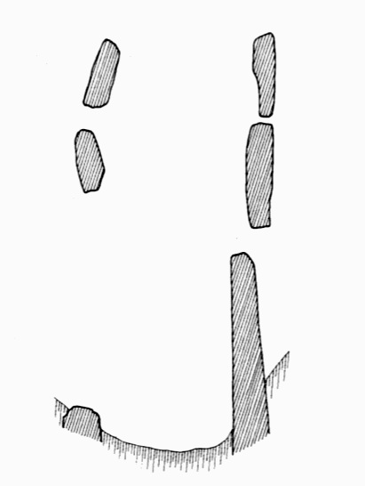
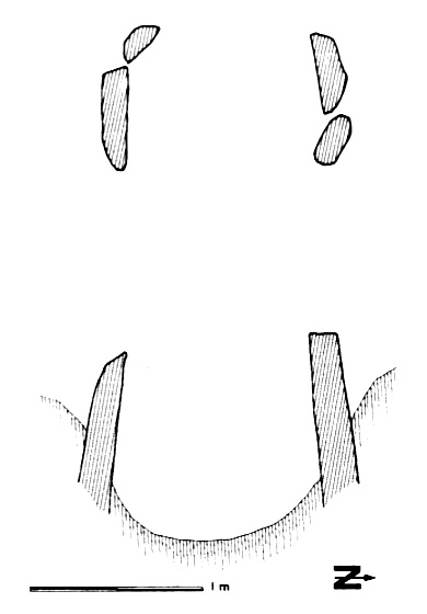
Fig. 9. —Plans and sections of polygonal chambers; Milleiroso A. Fig. 10. —Plan and sections of polygonal chambers: Milleiroso B.
Dimensions of the tumulus diameter E-W, 8 m; diameter of the pit 1,50 m; height. 1,20m.
Tumulus B. At about twelve meter to the N of tumulus A, conserving four slabs of its chamber, mostly covered by vegetation; they seem to be part of a polygonal chamber, of 1,50 m by 1 m in its internal dimensions. The height of the largest slabs measure 1,30 m (Fig.10).
Dimensions of the tumulus: diameter E-W, 17 m; diameter of the pit 2,50 m; height. 1,70 m.
Tumulus C. Between the Pico Milleiroso and the Pico Carondio. Plundered pit that is prolonged toward the South, eight flagstones of slate, and other de quartzite, fallen over the tumulus.
Dimensions of the tumulus: diameter E-W. 10 m; diameter of the pit 2 m; height 1 m.
19. Tomb of the Marco de Carondio.
Coordinates: 3º04'10" long. W; 43º19'10" lat. N; Altitude 1.150 m.
A tumulus on the mountain of Carondio, between the peak with this same name and that of Sorribas; the terrain is completely barren because of forest fires that burnt the place. El Marco, or the “milestone”, was slab of slate of 2 m high by 40 cm width, stuck into the central pit of the tumulus; presently it lays fallen down on the ground, at some five meter toward the east. The dug-out pit shows signs of recent enlargement, and a part of the tumular mass was affected by firebreaks.
Dimensions of the tumulus: diameter of the. E-W, 12 m; diameter of the pit 3 m; alt. 1,40 m.
20. Tombs of the Campo de Entrerríos.
Coordinates: 3º4'55" long. W; 43º19'30" lat. N; alt. 925 m.
Three tumuli, one of them being the Dolmen of Entrerríos, placed in the wide hill of Entrerríos, to the west of Pico Carondio (16).
Tumulus A. At about twelve meter to the N of the way, with a largely uncovered mass. Between the tumulus and the way and ancient boundary wall exists, formed by slabs that are stuck into the ground for which perhaps dolmenic orthostats have been used.
Dimensions of the tumulus diameter E-W, 10 m; height 40 cm.
Tumulus B. At 25 m to the west of tumulus A, and stuck to the south border of the way, that slightly shortens the tumular mass. Above this the Dolmen de Entrerrios, or “Llastra da Filadoira” stands outf.
The dolmen is known since the end of the 19th century, when Acevedo and Huelves drew its plan (17); already back then it was incomplete, several orthostats of the north side are missing. Later the larger of the two covering slabs came down—a state in which it already was when visited by Jordá in 1962 (18)—but it was put back into its place again the following year, by the locals of the area who used the dolmen as shelter.
The plan of the dolmen is polygonal (Fig. 1l), with the entrance space situated in the east side, opposite to the orthostat with the largest size; presently the orthostats of the north side are missing, except the one closest to the entrance; the south side consists of four slabs plus two more of smaller dimensions which are situated against the two orthostats that flank the entrance, forming a rudimentary corridor. The original entrance is covered as an amplification of the space of the chamber on the north side and the floor of the dolmen were deepened considerably (19).
The orthostats preserve their original height, except number 2 and 4, which upper sides are fragmented. Its height increases from the entrances to the end of the chamber.
The covering consists of two large slabs of different sized stones of slate, in contrast to the orthostats, that are of quartzite. The smaller slab covers the entrance area, held up by the orthostats that border on it, the larger covering that is carried on top of this slab and above the large west orthostat. The original covering is complemented by another large slab, similar to the larger of the ones conserved, and that would have covered the northern side of the chamber (Fig. 12). The larger slab is realized in slate with a very rough surface, different from the other covering, and in its superior side shows several small holes.
The origin of the lithic material of the quartzite orthostats appears to be from the surface called Peneos Molles, on the slope that descends from the hill de Carondio. For the slate of the larger covering Jordá points at Pico Castel, but we have not been able to prove that from our end. The use of these two materials show the preference for the more resistant quartzite for orthostats, which must support the weight of the covering and of the tumular mass; slate, that is lighter and easier to extract because of its natural flaking into layers, gives the possibility to obtain large slabs for the use as covering.
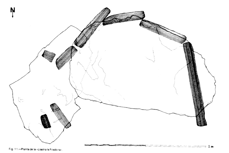
Fig. 11. —Plan of the "Llastra the Filadoira".
Dimensions of the tumulus: diameter E-W, 16 m; alt. 1,20m.
Dimensions of the chamber: space interior length max. 2,50 m; width max. 1,70 m; height from the ground to the lower surface of the larger covering, 1,55 m; of the smaller covering, 1,35 m.
Dimensions de the orthostats: n.º 1, height 1,35 m; width 1,40m; thickness 0,18 m; n.º 2, alt. 0,90 m; width 0,83 m; thickness 0,12 m; n.º 3, alt. 1,32 m; width 0,70 m; thickness 0,15 m; n.º 4, alt. 1,20 m; width 0,80 m; thickness 0,18 m; n.º 5, alt. 1,05 m; width 0,36 m; thickness 0,18 m; n.º 6, alt. 0,83 m; width 0,45 m; thickness 0,16 m. Slabs covering: the smaller, length max. 1,90 m; width 1,17 m; thickness 0,23 m; the larger, long. 2,49 m; width 1,50m; thickness 0,20 m.
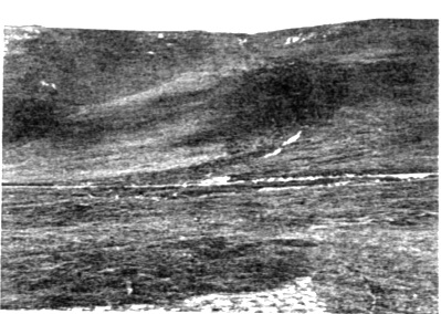
Photo 5.—The group of Penas Malas; in the background the Tombs of Llamadonas
Tumulus C. Fifteen meter to west of the anterior, is known as “the tomb of Entrerrios”. The tumular mass is well conserved, showing two slabs in the deepened pit.
Dimensions of the tumulus: diameter E-W, 17 m; diameter of the. pit 4 m; alt. ,-60 m; Depth of the pit 1,30m.
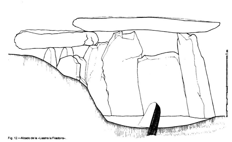
Fig. 12.—Frontal view of the "Llastra da Filadoira".
GENERAL CONSIDERATIONS.
The tumuli of the Sierra de Carondio are part of a series of morphologically similar structures that exists in all of the Asturian territory and are known essentially thanks to the field work laid out by José Manuel González (20). Such tumuli can generically be related with the existent ones in the peninsular NO, but for the moment we lack better precisions that help us to place them chronologically and culturally. Realized excavations permit us to assume the existence of dolmenic tumuli, that is to say, with lithic chambers in their interior, alongside others that lack the structure of this type; although, and again, we cannot establish cultural correlations. Our study only pretends to describe the situation and morphology of a tumular group.
SPATIAL ARRANGEMENT.
We have already pointed to topographic characteristics of Sierra de Carondio; on it 34 tumuli are located that mark the way that runs in length along the Sierra (21), and in a few cases over secondary ranges of smaller lay-out. The tumuli in their majority are either located in places of passage between hills (“collados”) or on slopes of little inclination and close to the way, and in general they are visually connected.
This way, the “Carreiriega de los Gallegos”, is the inheritor of a very old communication way, that takes advantage of the natural conditions of the Sierra, that make it suited for passage through the high zones that are more even than the slopes.
In themselves these high parts are much easier to deforest, a circumstance to which the height contributes (925m at Entrerrios and 1.150 at Marco de Carondio) which favors it for pastural use (22) in which the way has played an important role when we think about seasonal migrations, temporal grazing, etc.. The tumuli, beside giving evidence of the higher zones’ occupation, emphasize the importance of the way for the herding populations who used it, through situating their funerary monuments in direct connection with it that also served as landmarks of their path.
GROUPINGS.
Of the 34 conserved tumuli, only 10 are found as isolated; the majority of the remaining cases are grouped as pairs. 14 tumuli, 6 of which are placed on opposite sides of the way; 6 other tumuli are grouped in triads. There only exists one case in which a larger number de tumuli are grouped: the four of Penas Malas, which, as we already have seen, form a totally exceptional case—not just because of its number but also because of the hierarchization of its components, and even because of the appearance of remnants of walls, although these possibly have pertained to a cabin of an era much later than that of the tumuli.
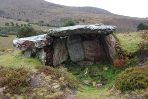
Photo 6.—Dolmen de Entrerríos.
SIZE.
The original dimensions of the tumuli have been thoroughly affected by erosion, plundering, etc., because of which we only can consider the current sizes as approximate, especially those of the diameter of the tumular mass; this oscillates between 8 and 20 m., except for the 4-5 m. of the minor tumuli of Penas Malas. The relation diameter-height is not constant, due to the various grades of destruction; height oscillates from circa two meter to less than half a meter.
MORPHOLOGIC DATA.
The tumular mass, of a circular plan or slightly ovular, does not show more precise external structural details; no slabs or walls forming a circle at the base of the tumulus paved for protection etc. can be seen. Only in a few cases in the composition of the tumular mass can be seem, based on small slabs mixed with earth, without holding any special arrangement.
Emphasize should be put on the systematic violation of all of the tumuli as can be evidenced from their central pits, and sometimes in the accumulation of materials proceeding from them that deforms the contours of the tumuli, and also due to the dismantling of the volumes of groups.
In many occasions the plundered pit shows the remains of the interior chamber—except for the dolmen de Entrerrios. In eighteen cases the tumuli’s stone slabs can be seen that originate from the chamber; eight cases have been completely destroyed and have displaced slabs laying around on the surface of the surrounding terrain.
Ten other chambers are still visible in their original place, although in some the original disposition cannot be made out. Those that we can identify, seem to correspond to the type, of small dimensions, of the polygonal plan: the chambers of Pico Milleiroso A and B‚ of Mollapán B, and those of Peneo Cortao. The other type shows a rectangular plan, formed by, at least, three flagstones, which corresponds with the idea of the cist. The chambers of the Peneo Conde A and B, of the Regu Buñu and possibly of the Pico Llangominos would be of this type. Eventually the disappeared instances of Veigosabades and of the Castellín appear to correspond to a dolmenic plan of larger size, judging from the Piedra Dolménica of Allande.
Finally, the fact is clear that in all recognizable cases of chambers, just as with the Dolmen de Entrerríos, the largest axis and the entrance opening of the Dolmen, are all oriented into a W-E direction.
(*) We want to give our thanks for the wonderful collaboration of Mara Herrero and Joaquín Lopez, just like the inhabitants of the area, and especially de D. José Arango, from Penouta.
NOTES.
(1) Mapa Topográfico Nacional 1:50.000 del Instituto Geográfico y Catastral, hoja n.º50. Cangas del Narcea.1.ª ed.1952.
(2) According to the information of D. José Arango, inhabitant of Penouta, who offered us all of his help.
(3) Information of D. Amador Mesa, neighbor of El Sellón.
(4) Joaquín José QUEIPO DE LLANO, V Conde de Toreno, Discurso pronunciado en la Real Sociedad de Oviedo en los años 1781 y 1783 por su promotor y socio de mérito, el Conde de Toreno... Madrid, Joachin Ibarra, 1785, Facsimile Ed., Oviedo, 1978, p. 43.
(5) Bernardo ACEVEDO Y HUELVES, Los vaquieros de alzada en Asturias, Oviedo 2.ª ed. 1915, pp. 279-281.
(6) Aurelio DE LLANO, Bellezas de Asturias, Oviedo, 1928, pp. 505-508, fig. 473.
(7) Conde de la VEGA DEL SELLA, La piedra dolménica de Pola de Allande, en Ipek, 1926, pp. 55-63. This deals about a slate slab with engraved decorations consisting of series of eggs and a serpentiform. It’s place of origin was specified by Antonio García Linares, in a message to Miguel Angel de BLAS, Algunos materiales megalíticos de Asturias, en Archivum XXII (1972). Oviedo 1972 p. 22, and to Emilio MARCOS VALLAURE in his notes about Discurso..., by QUEIPO DE LLANO p. 59; D. José Arango affirms this fact, and the inhabitants of the area still remember the transport of the stone on a oxen cart from El Castellín to the path’s junction with the road from La Pola to Puerto del Palo. For a recent review of the motives engraved into the flagstone: Miguel Angel de BLAS, Arte parietal megalítico en Asturias, in: IV Congreso Nacional de Arqueología de Portugal, Faro, 1980 (being printed).
(8) Francisco JORDA CERDA, Notas sobre la cultura dolménica asturiana, en Archivum XII (1963).
(9) Antonio GARCIA LINARES, voz Allande, en La Gran Enciclopedia Asturiana, tomo I, p. 179.
(10) Reference to the meridian of Madrid.
(11) Antigua is the local name for the channels laid out for the water supply for the Roman mining works, that in many occasions were used as roads afterwards. The ones existent in the Sierra del Palo have partially been studied by P.R. LEWIS v G.D. JONES, Roman Goldmining in north-west Spain, en Journal of Roman Studies, n.º LX, 1970, pp. 178-181.
(12) José Manuel GONZALEZ Y FERNANDEZ-VALLES, Recuento de de los túmulos sepulcrales megalíticos de Asturias, in Archivum. XXIII. Oviedo, 1973. p-.5-42 “In La Labrada, district of Santa Colma. 1 tumulus”, p. 32.
(13) GONZALEZ, Recuento, p. 32. “In a pass where the road of S. Coloma crosses through, situated in the vicinity of Penouta, 2 tumuli”.
14) GARCIA LINARES, Allande, p. 179. cita “the interesting necropolis of Carondio, with archaeological remains in El Rebollo, La Llamadona, Pena del Conde and Veiga Abades”. Perhaps El Rebollo corresponds with the group of Penas Malas, because of its proximity to the village with this name.
(15) The Conde de Toreno refers to these tumuli: “In the same parish above the village of Bendón, next to a cabin about which de Casa Esteve says that a large stone was found there that was named “del Conde” [i.e. ‘the Count’s Stone’]. Nearby several stone sepulchers of gentiles are found...” QUEIPO DE LLANO. Discurso, Pág. 43.
(16) GONZALEZ, Recuento, p. 31 “In Entrerrios, between the places of Herias and Barandón, 1 dolmen». DE LLANO, Bellezas..., p. 506. foot of photograph n.º 473: “...close to this dolmen, are the remnants of another two...” More to the west of the Campo de Entrerrios, in Penas Longas and Las Arcas, there are more tumuli that we were unable to visit.
(17) ACEVEDO, Los vaqueiros..., pp. 280-281.
(18) JORDA, Notas.
(19) In the photographs of Aurelio de Llano the primitive disposition of the cover stone can be seen, that coincides with the current, but likewise the lesser profundity of the internal pit of the chamber may be noticed, that maybe was filled up at the same time when the cover stone was put into its place.
(20) GONZALEZ, Recuento...
(21) References to these tumuli in bibliographies are very vague, and are not easy to relate with the ones already located with the ones described by us. José Manuel González situates thirteen tumuli related with those of Carondio in three counties: in Allande the ones of La Labrada and El Pozo, and another one “situated between kilometers 5 and 6 of the road of S. Coloma”, which corresponds to the pass of Santiellos, which perhaps refers to Pico Cuayeiro; in Villayón six tumuli “on the northern side of the Sierra de Carondio, territory of Entrerrios”; in Illano four tumuli “on the southern slope of the Sierra de Carondio”. These two last localizations have been taken out of the unedited manuscript of P. Alejandrino García MARTINEZ Prehistoria sobre el occidente de Asturias, 1929.
(22) Until recent times this pastoral activity survived in area, as it was the primary occupation of the vaqueiros de alzada [nomadic cowherds].